At the beginning of 2021, President Joe Biden exclaimed that “science is back” as we continued our efforts to address the COVID emergency. That phrase continues to ring true across the federal government. Science and its applications are being used at every agency—to address public health challenges, build new transportation infrastructure, inform policy decisions and tackle the climate crisis.
At the Department of the Interior, using the best available science isn’t just critical, it is a necessity for everything we do. One area in which our premier scientists are shining? The observations of Earth from outer space that we serve up to the public.
Recently, the Interior Department’s U.S. Geological Survey (USGS) assumed operations of Landsat 9 from NASA, which built and launched it last year. This satellite helps to monitor Earth’s land, water and other natural resources. Landsat missions support environmental sustainability and climate resiliency through high-resolution satellite imaging. The Landsat program isn’t new; in July we celebrated 50 years of the NASA and USGS Landsat partnership that has helped us understand our planet and the changes that are occurring on it. That partnership has propelled research and observation forward over the years through the launch of successive Landsat satellites, each replacing its predecessors and working in tandem with new capabilities and strengths.
Though science is not a passion I pursued, I come from people who were among the first Earth observers, biologists and agriculturalists. Through generations of studying the cycles of the seasons and the flow of the waters and observing their environments, Indigenous peoples built complex communities to manage Earth’s natural resources. They mapped the stars and watched the moon to understand when to plant and harvest, and they practiced conservation as the first stewards of our lands and waters.
The incredible possibilities that lie ahead for the Landsat program are an extension of my history and our history as a nation. What the satellites have shown us is that climate change’s effects on the U.S. are undeniable.
Last year I had the opportunity to attend and witness the historic launch of Landsat 9, the latest in the Landsat series. It was nothing short of amazing. I toured the mission control center and met a young scientist from the Navajo Nation living far away from home. She uses Landsat imaging to see her home from more than 1,000 miles away, and with such data, she works to help her community manage water resources in the face of a changing climate. This is the power and beauty of science at work.
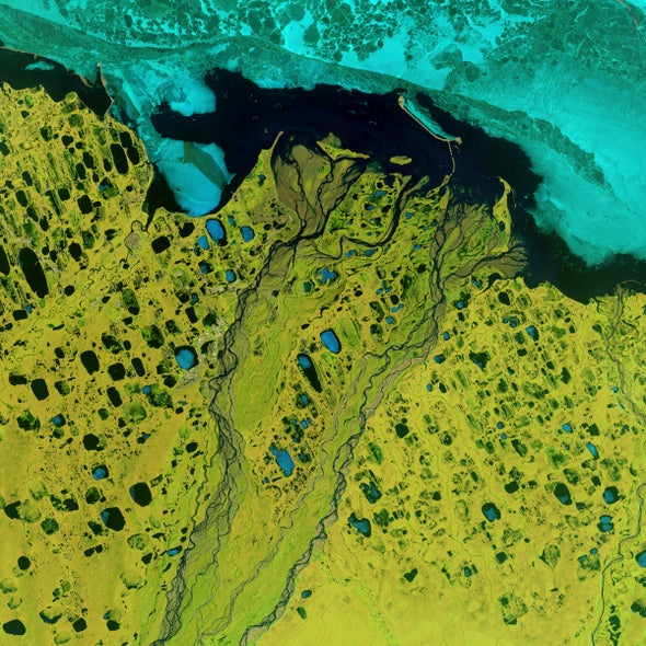
All around the globe, researchers, analysts and experts use Landsat and other imagery to interpret what is happening on the Earth today and compare it with the 50 years of data that the Landsat program has collected.
But as exciting as that is, the forecast is grim.
The images show the changes to our water resources, increased wildfire damage, amplified coral reef degradation, diminishing glaciers and ice shelfs, and rapid tropical deforestation. This is a reality that most people know all too well. As I travel across the country, I meet with communities who feel those changes.
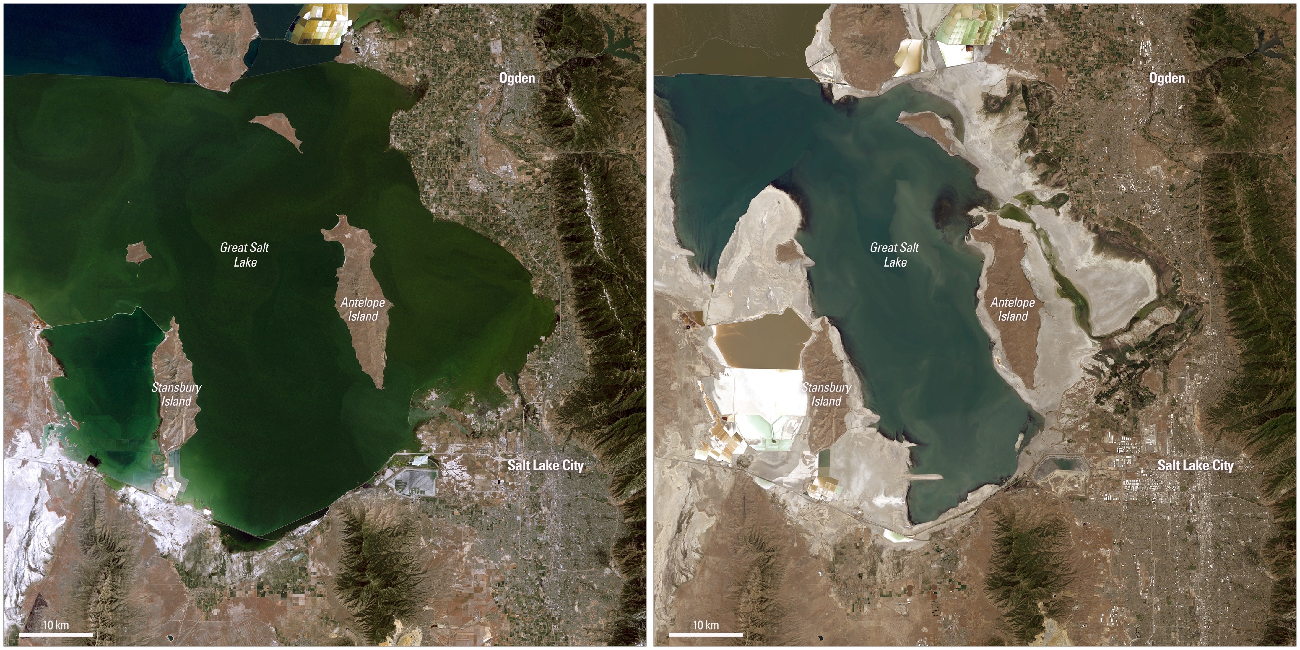
Water allocations are at historic lows across the nation, creating an urgent need to minimize the effects of drought and develop long-term plans to facilitate conservation and economic growth. Sea-level rise is submerging coastal communities, displacing and endangering residents. Wildfire seasons are longer and longer, threatening homes and businesses.
Science can help us to address these challenges and plan for our future. The stunning Landsat images of our planet can help us better support environmental sustainability, climate change resiliency and economic growth—all while expanding an unparalleled record of Earth’s changing landscapes.
This science-based program and those like it across federal agencies are powerful tools in our efforts to responsibly manage our resources. Their prioritization helps to demonstrate the Biden-Harris administration’s commitment to lead with science. So, too, the incredible resources provided through the president’s Bipartisan Infrastructure Law and Inflation Reduction Act will help us develop longer-term sustainability measures to respond to climate change, including building more resilient communities and protecting our natural environment.
Landsat NEXT is the next mission we will develop with NASA. Its improved observation capabilities will power better science and decision-making for the next 50 years and beyond to ensure communities are ready to adapt to our changing climate and policies are working to restore balance to nature. Science is indeed back, and it’s helping us chart our path to a brighter future.
This is an opinion and analysis article, and the views expressed by the author or authors are not necessarily those of Scientific American.
A version of this article with the title “Satellites Can Help Us Fight Climate Change” was adapted for inclusion in the January 2022 issue of Scientific American.
 Rights & Permissions

