For more than a century, the 3.5 million miles of rivers that snake across the U.S. were treated like open sewers and garbage cans, leaving them steeped in oil, paint, fertilizer, feces and other refuse. Fires that ignited riverine trash were widely considered an acceptable cost of industry, a sign of abundant jobs and economic growth. And there was a common (and erroneous) belief that “dilution was the solution to pollution,” meaning that waterways had an endless ability to absorb our waste and flush it away.
But by the 1960s there was a growing realization that the nation’s waterways were in crisis, left unusable for drinking water and toxic to wildlife. To confront the problem, Congress—with strong bipartisan support—enacted the Clean Water Act (CWA) 50 years ago this Tuesday. With the goal of allowing rivers to become swimmable, fishable and drinkable once again, the legislation made it illegal to discharge pollutants into waterways without securing a permit. Though the law has resulted in significantly cleaner waterways, there are still decades of cleanup ahead for many of them. Pollution still washes into streams, rivers and lakes from sources that are not covered by the CWA, such as urban and agricultural runoff. And rising temperatures are stressing aquatic ecosystems.
The CWA is still seen as critical for cleaning up the most egregious and obvious pollution, though. “It’s a legacy for our children,” says Dean Naujoks of the Potomac Riverkeeper Network (PRKN), a nonprofit advocacy group and a member of the Waterkeeper Alliance, a national network of organizations that work to protect the public’s right to clean water. As we mark the CWA’s 50th anniversary, Scientific American takes a look at the state of seven U.S. rivers.
Potomac River
Location: flows through or borders Maryland, Washington, D.C., West Virginia and Virginia
.jpg)
The Potomac has long been known to many as the “nation ’s river,” and in 1969 President Lyndon B. Johnson called it “disgraceful.” A river “rich in history and memory which flows by our nation ’s capital should serve as a model of scenic and recreation values for the entire country,” he said. Now it’s at least getting there. The nonprofit Potamac Conservancy calls it a river “on the mend, but not in the clear.”
“We don’t see raw sewage and toilet paper and green sludge in the river [anymore], but we’re seeing a lot more trash and pollution that’s linked to stormwater from urban areas,” PRKN’s Naujoks says, “and plastic pollution—a massive problem.” Additionally, agricultural pollution has left miles-long stretches of the river with toxic algal blooms.
Weekly bacterial testing shows that much of the river is safe to swim once again. But to hasten more progress on that front, Naujoks’s organization is pushing surrounding cities to curb pollution. According to the District of Columbia Water and Sewer Authority, its Clean Rivers Project will eliminate 96 percent of Washington, D.C.’s sewage discharges into the Potomac and Anacostia rivers and Rock Creek by 96 percent by 2030.
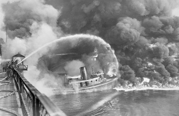
Cuyahoga River
Location: runs through northeastern Ohio, emptying into Lake Erie at Cleveland
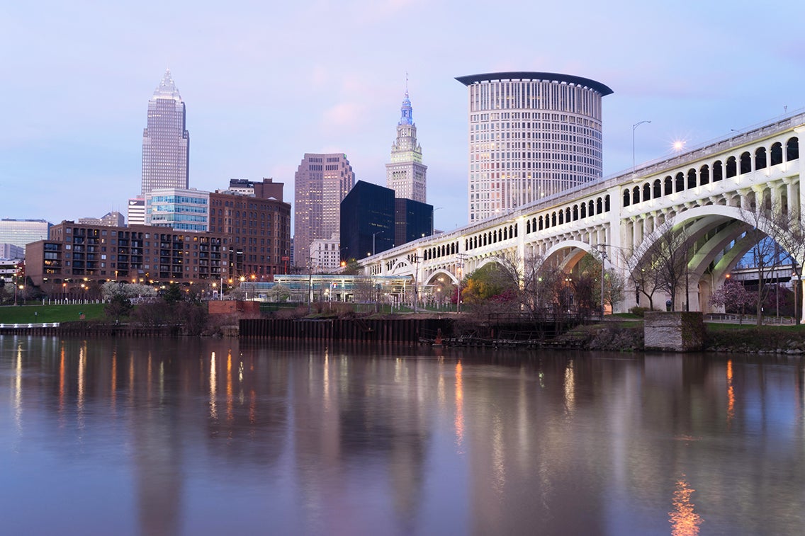
Considered a historical marker for the environmental movement, the Cuyahoga became known as the “burning river,” the poster child for the polluted state of U.S. rivers. Beginning in 1868 and for more than a century, volatile chemicals and debris floating on the surface of the river periodically caught fire. But it wasn’t until a high-profile 1969 fire that the nation began paying serious attention. After the Clean Water Act stopped unfettered industry discharge, and through the collaboration of local, state, federal and international organizations, “the river is coming back,” says Jacki Zevenbergen, vice president of the nonprofit advocacy group Friends of the Crooked River. Recreational activities such as kayaking and fishing have resumed. Agricultural runoff remains a major concern, though, and is contributing to toxic algal blooms in Lake Erie—including one in 2014 that fouled Toledo, Ohio’s drinking water.
Mississippi River
Location: borders or runs through Minnesota, Louisiana, Wisconsin, Illinois, Kentucky, Tennessee, Mississippi, Iowa, Missouri and Arkansas
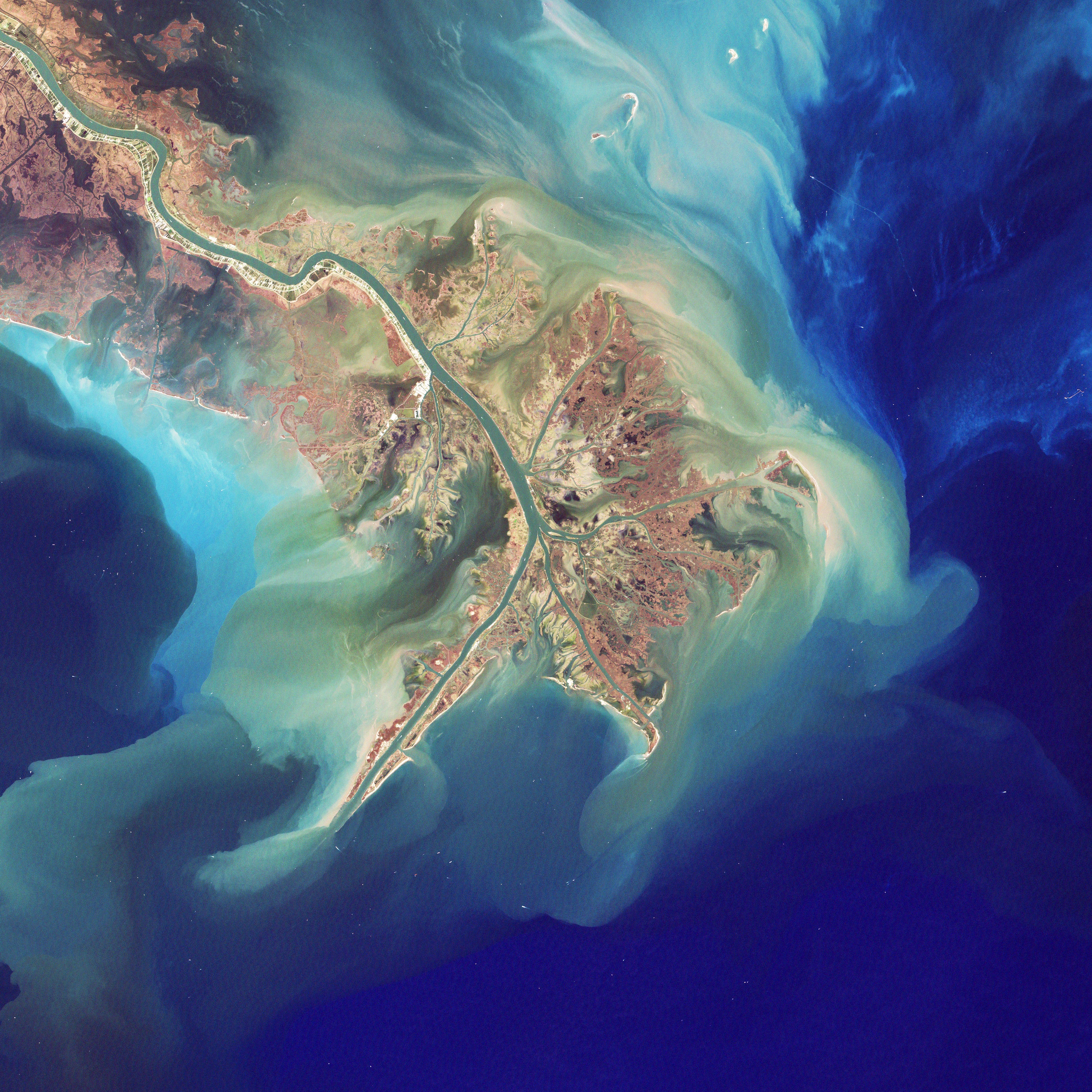
Our nation’s largest river, the Mississippi, has a watershed that stretches over 1.15 million square miles across 31 states from the Rocky Mountains to the Appalachian Mountains. Compared with its state before the CWA, the river now has lower levels of pollutants from industrial facilities, and wastewater and fish consumption advisories have declined. But microplastics and agricultural runoff remain unregulated challenges, says Olivia Dorothy, director of the upper Mississippi River Basin at the nonprofit American Rivers. Nutrient-rich agricultural runoff washing into the river has fed a Connecticut-size dead zone—a stretch of water with poor oxygen levels that can be lethal to marine life—in the Gulf of Mexico, into which the Mississippi empties out. The river itself suffers from its own smaller dead zones. The runoff involved is known as “nonpoint source pollution” because it does not come from a single factory or pipe.
Complicating efforts to improve the river’s health are the varying politics of its 10 bordering states. As a solution, American Rivers has petitioned the federal government for a geographical program office like those created for the Great Lakes and the Chesapeake Bay. Such a program would cut through jurisdictional issues and “offer us a chance to fund projects and programs that address these ‘nonpoint’ sources of pollution and restore lost habitat to improve water quality, among other benefits,” Dorothy says.
Neuse River
Location: North Carolina
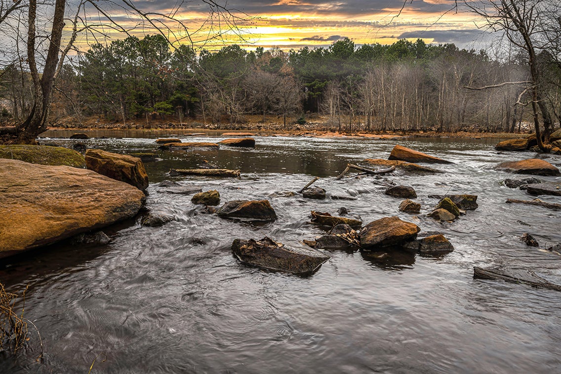
Following a century of unabated pollution from North Carolina’s manufacturing and textile industries that occurred before the Clean Water Act, the Neuse River reached a nadir in the 1990s because of poor wastewater treatment, urban development, and agricultural pollution. “Millions of fish were just being washed up on the shore,” says Peter Raabe, American Rivers’ senior director of southeastern Appalachia and the Carolinas. The river, which provides drinking water to the majority of the 2.5 million people in its watershed and is vital to North Carolina ’s $1.7-billion fishing industry, landed on the organization’s Most Endangered Rivers list in 2018.
In terms of the impact of the Neuse’s pollution, “major environmental justice issues remain,” Raabe says. The CWA drove investment in water infrastructure, he says, but smaller rural communities—which are disproportionately communities of color—often lack the resources to apply for grants to make improvement.
Snake River
Location: runs through Wyoming and Idaho, along the Idaho-Oregon border and into Washington State, where it flows into the Columbia River
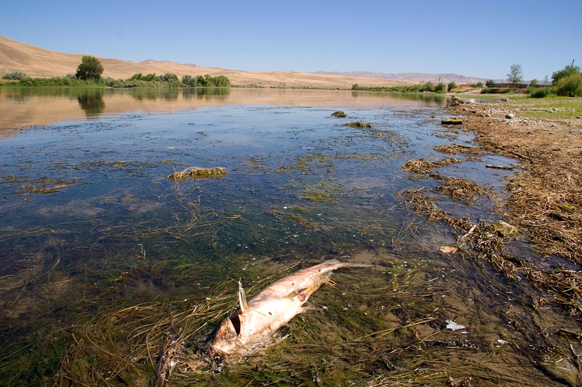
The largest tributary of the Columbia, the Snake River is suffering from rising water temperatures that are affecting native fish populations. Before European colonialists arrived, the river teemed with millions of estimated salmon and steelhead trout. An analysis the nonprofit Save Our Wild Salmon suggest that by 2017 they numbered in the mere thousands. Indigenous tribes in the area have treaties with the federal government guaranteeing them fishing access on the river, making the declines “a significant tribal rights issue,” says Kyle Smith, Snake River director at American Rivers.
The Environmental Protection Agency has linked the warming water to climate change and to four hydropower dams along the river’s course. The dams have “turned the Snake into a series of still-water reservoirs—basically four bathtubs out in the sun all summer,” Smith says. The U.S. Army Corps of Engineers, which operates the dams, “takes its environmental stewardships responsibilities seriously and continually works with state and federal regulators to ensure our operations are in line with current environmental standards,” says spokesperson Matt Rabe. Unless the dams are removed, Smith says, salmon and steelhead face the threat of extinction.
Hudson River
Location: runs through New York State and along its border with New Jersey
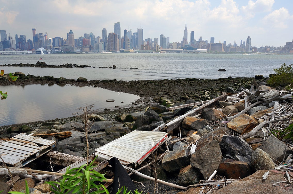
Though industries and municipalities have stopped treating the Hudson like a dump, large segments of the 300-plus-mile river remain under threat. It is the nation’s largest Superfund site because of an estimated 1.3 million pounds of PCBs (polychlorinated biphenyls) dumped by General Electric (GE) for 30 years. This began in 1947 and ultimately killed the river’s once-robust fishing industry. Cleanup of the river’s upper section started in 2009, and the EPA and GE finally agreed to a scientific assessment of the lower river in 2022. Though GE did not provide a specific statement in response to a request for comment, a GE spokesperson says the company stands by comments made by the EPA in 2015 that “the Hudson River PCB Superfund dredging project has been a success.... This project is the most extensive dredging project undertaken in the nation, and its success is a historic achievement for the recovery of the Hudson River.”
The Hudson still has a sewage discharge problem because 60 percent of New York City is served by a combined sewer system that handles rain runoff and sewage in the same piping. But rain can trigger an overflow of the city’s system into the river and New York Harbor. “Over the course of the year, it’s [the volume of] 72 Empire State Buildings full of untreated wastewater and rain—that’s what goes into the waterways around New York City still,” says Tracy Brown, president of Riverkeeper, a nonprofit advocating for the protection of the Hudson River. Ted Timbers, a New York City Department of Environmental Protection (DEP) spokesperson, says about 90 percent of that is rainwater and 10 percent is sewage.
Solutions include sewage tunnels and tanks that would capture sewage and pump it to treatment plants once rain has subsided. These are expensive projects that can take decades to complete, but some have already been built or are underway, Timbers says. “New York Harbor, including the lower Hudson River, is cleaner today than it has been since the Civil War,” he says. “We know this because DEP scientists regularly test the health of the harbor, but all New Yorkers are witnessing the return of whales, dolphins and seals to the cleaner waters of the Big Apple.” So-called green infrastructure solutions, some of which are already underway, could also help. They include using sidewalk gardens to absorb precipitation, and many of these projects have also already been deployed. The Riverkeeper is still pushing for more aggressive overhauls of the city’s sewage system to speed up the river’s recovery process.
Saint Croix River
Location: runs through Wisconsin and Minnesota
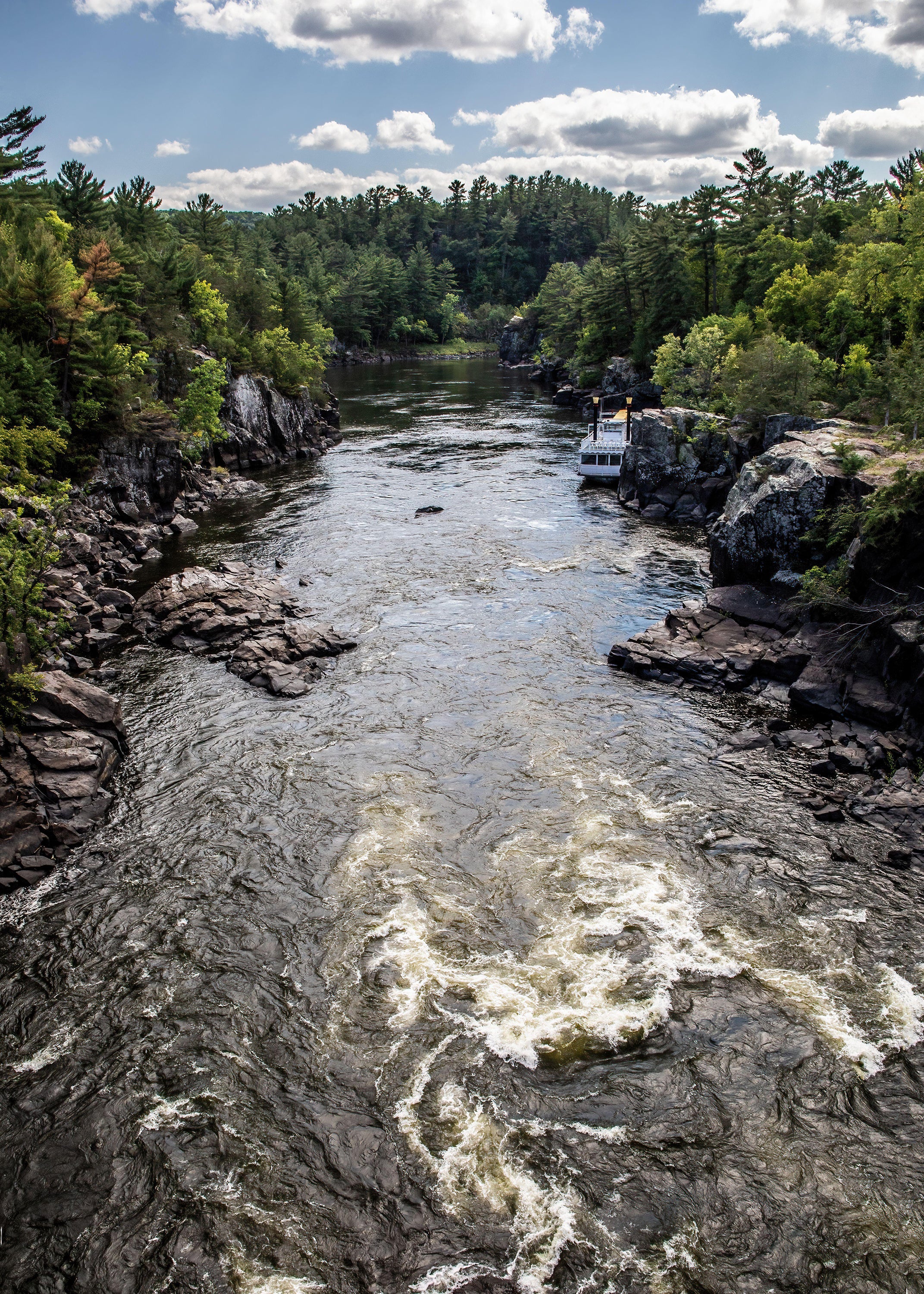
“If you’re comparing [the Saint Croix] to other rivers, we overall have outstanding, great water quality,” says Katie Sickmann, natural resources manager at the nonprofit Wild Rivers Conservancy. With a watershed that covers about 7,600 square miles, the Saint Croix is one of the original eight U.S. rivers designated as part of the Wild and Scenic Rivers Act. This legislation, passed in 1968, aimed to preserve “selected rivers” with the most “outstandingly remarkable scenic, recreational…, cultural, or other similar values” for future generations. While parts of the river are still “considered impaired” because of agricultural runoff, Sickmann says the Saint Croix’s “world class mussel population” is helping because these bivalves are living water purifiers.
 Rights & Permissions
