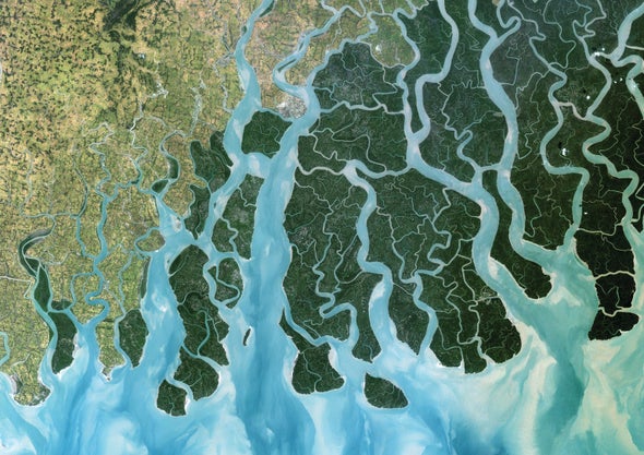
Earth's river deltas have long been home to vital ports and wetlands. Despite sea-level rise, these economic and ecological hotspots have expanded on the whole in recent decades, scientists have found—but this trend is unlikely to last. Geoscientist Jaap Nienhuis of Utrecht University in the Netherlands and his colleagues have pinpointed almost 11,000 river deltas in data from satellites and worldwide field studies. Using computer simulations, they estimated how tides, waves and human activity upstream affected each delta's size and shape from 1985 through 2015. In many watersheds along South America's eastern coast, as well as Asia's eastern, southern and southeastern coasts, the researchers found that deforestation increased sediment carried by rivers—and that deltas have grown accordingly. (The Ganges delta, as seen here, is one such example.) In North America, however, dams have trimmed the volume of sediment available to nourish many river deltas.
Although sea levels rose about 10 centimeters during the period studied, river deltas in aggregate gained about 54 square kilometers of new land each year, the researchers reported in January in Nature. But they say that growth is most likely only a short-term phenomenon. Molly Keogh, a wetlands ecologist most recently at Tulane University, who was not involved in the study, agrees; she notes that sea levels are projected to increase about 60 centimeters by the end of the 21st century. Also, delta sediments are notorious for compacting under their own weight over time.
This “double whammy,” as Keogh describes it, will lead to an overall shrinkage of river deltas across the world in the coming decades. Beyond the loss of low-lying infrastructure and fisheries, consequences could include the inundation of major population centers and agricultural regions.
 Rights & Permissions
