When conditions align perfectly, disaster comes rushing across the Great Plains: a supercell storm, made distinct with its wide, anvil-shaped formation at its top, can unleash hail, lightning and tornadoes.
Though the storms are relatively rare, they can last hours; a supercell thrives on upward-moving warm air and downward-moving cold air, and as the two streams travel their separate paths, the latter avoids dampening the former. And though only about 20 percent of supercells generate tornadoes, they account for the majority of the twisters that tear up the U.S. each year.
In short, a supercell on the horizon is an ominous sign. But meteorologists are not sure what makes the storms turn deadly or how often they do so. That is why researchers have spent decades flying into and driving by the extreme storms, evaluating what it takes for a supercell to create hazardous conditions, tornadoes in particular.
The hope is that with a better sense of when a tornado will touch down, officials can warn the public earlier and increase locals’ trust about the severity of the coming danger.
Supercell near West Point, Neb. To get a better idea of when the storms create tornadoes, researchers fly drones 2,500 feet off the ground and into supercells rumbling across Nebraska, South Dakota, Kansas and several other states.
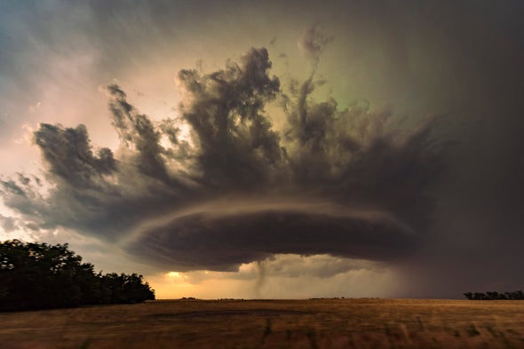
Tornadic supercell storm moving over the Great Plains during sunset. Historically, tornadoes plague the Great Plains the most, but evidence is building that the extreme weather events are becoming more frequent farther east, such as in Mississippi, Alabama and Tennessee.
High-precipitation supercell moving through the Nebraska Sand Hills. Supercells generally produce the largest, fastest-falling hail. Ice balls in the strongest storms could be two to four inches across, crashing down between 44 and 75 miles per hour.
Tornado funnel and debris cloud under a supercell in McCook, Neb. The dark cylinder around the tornado base is a debris cloud, a swirl of stirred-up dirt and wreckage that can swell to twice the width of the twister itself.
Supercell moving over the Great Plains. Brewing within the storm is a draft with the right rotation, size, depth and duration for Doppler radar to label it as a mesocyclone: the precursor to a tornado.
Slow-moving tornadic supercell speeding up near Bartlett, Neb. A slower thunderstorm crosses the landscape at about 12 miles per hour, and the fastest supercells can reach between 40 and 50 miles per hour.
Supercell mushrooming during sunset in Bledsoe, Tex. National research efforts into thunderstorms began with the Thunderstorm Project in 1945. The weather events were seen as a threat to flights—so naturally, the project flew planes directly through storm clouds.
Supercell and tornado sweeping across Lamar, Colo. The National Weather Service rates tornado intensity with damage surveys done after the fact. New research suggests that for supercell-spawned tornadoes, the traditional assessment method might underestimate wind speeds.
Tornado-warned supercell headed toward Enid, Okla. Someone has to witness a tornado for it to be recorded. Because population density has increased since the early 1900s, it is not clear if the weather is more common or if more people are around to see it.
A version of this article with the title “Science in Images” was adapted for inclusion in the November 2021 issue of Scientific American.
 Rights & Permissions
